Map of Visited Canadian Provinces

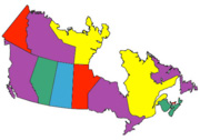
Use this free mapping tool to display the provinces that you have visited, driven or ridden through. RV drivers, motorcycle riders, car touring enthusiasts: Create a color province map to show where you have travelled.

Visited Provinces Map    Instructions: Check the provinces that you have visited, driven through, stayed in, rode through, you-name-it! After selecting the provinces that you have visited, select a map size, then click Draw Map to create your own customized map of visited provinces. Are you a recreational vehicle owner? Do you tour in your car or on your motorcycle or trike? Display where you have been on your website! Right-click on your customized map to copy the map or save it to your hard drive. Then upload your customized visited provinces map to your own website, Facebook or MySpace page.

Canadian Provinces I Have Visited:

Alberta
British Columbia
Manitoba
New Brunswick
Newfoundland and Labrado
Northwest Territories
Nova Scotia
Nunavut
Ontario
Prince Edward Island
Quebec
Saskatchewan
Yukon Territory
Map size:
Visited States Map
Like to travel? Travel with less worry with a top-rated radar detector from 1stRadarDetectors.com. In a perfect world, no one would ever speed. But we may inadvertently speed in a moment of distraction, or while passing another vehicle. A top-rated radar detector from 1stRadarDetectors.com will allow you to know when you're approaching a speed trap so you can check your speed and keep safe.